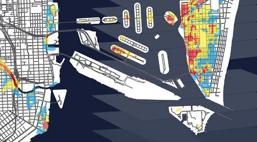
Our friends at E Miami Condos created
a map to visualize how specific condos will be hit most
based on increases of two feet, three feet, and four feet,
utilizing Florida International University’s School of
Journalism & Communication’s web-based app that allows
people to input an address and see how many feet above sea
level a property is.
Among the most susceptible areas are along the Miami river,
Edgewater, and West Avenue on South Beach. If pollution
continues at its current rate, experts project an increase
of 22 to 52 inches by 2100. |
|
This Map Shows When Rising Sea Level Will Affect
Your Miami Condo
|